
With thanks to the Pillbox Study Group
http://www.pillbox-study-group.org.uk/
There is something about this island of ours that has enticed the Continental adventurers to cross some of the most dangerous and unpredictable waters to live here. Whatever lay beyond the shores of Albion, Englaland, Britannia, or whatever the invaders named the land, it must have been desirable because the indigenous people could get quite upset at the audacity of any invaders who travelled across the Channel or North Sea.
After the sinking of the Continental Landbridge (Doggerland) beneath increasing sea levels and the Storegga Slide tsunami, we have been invaded by ship and people from Continental countries. Before the Romans invaded, most of the British were Celtic and, perhaps, can be considered the original Britons. There is very little knowledge of when and how the Celts arrived and what came before.
Initially, the Romans did not intend to conquer Albion but wanted to establish a trading partnership. It was not until Claudius’ time who, at the request of some of his Celtic allies, established dominance over the land. There was one exception to this dominance, and that was uprisings by the Queen of the Iceni named, and often mispronounced, Boudicca. She was defeated on Watling Street, near St Albans, and the Romans kicked on from there. They did not have it all their way and needed to build a wall across the northern part of the country to stop another set of Invaders, they called Picts, from Scotland. They did invade southern Scotland, but they were beaten back by the Picts, not a nation but a collection of tribes who often like to go into battle nude. It must have been freezing around the Trossachs.
After beating Boudicca and keeping the Picts to the other side of the wall, the Romans, many of whom did not come from Rome, enjoyed a few hundred years of relative peace and calm building villas with central heating. That relative period of peace lasted until they were troubled by serious barbarian raids from around AD 360. Picts (northern Celts) from Scotland, Scots from Ireland (until AD1400, the word ‘Scot’ meant an Irishman) and Anglo-Saxons from northern Germany and Scandinavia all had a go at the Romans. They came to plunder the accumulated wealth of Roman Britain. The Roman legions began to withdraw from Britain in AD383 to secure the Empire’s borders elsewhere on mainland Europe. By AD410, all Roman troops had been removed, leaving the Britons and the remaining Romano-British to fend for themselves.
When the Romans departed, the Country descended into what was know as the Dark Ages. Now here is a bit of an embarrassment. Early British History was never on the curriculum at my early schools, so I thought that the Dark Ages was precisely that, a time when the land was dark. However, the Dark Age was caused by the Romans taking their tidy knack of recording history back with them, so that very little is known of this time. The thing that is known is that the Angles, Saxons and Jutes used this period to establish their ownership. They had worried the Romans before they withdrew, but it was after their departure that they really got into their stride.
The Anglo-Saxons are synonymous with the Deben Peninsula. When the mates of Rædwald decided to drag a 27-metre boat up Ferry Hill or Apricot Hill to the Burial Site at Sutton Hoo, it set up a concrete association of this area with the Anglo Saxons. They remained as residents until around AD1100. You cannot go far in this area without being faced with Anglo Saxon history. As you try to get off the Peninsula, you are met by a sizeable wooden sign announcing the entrance to Sutton Hoo with the relief picture of Rædwald’s helmet. The construction of the replica of the Sutton Hoo burial ship is taking place in the long shed in Woodbridge. The Netflix film ‘The Dig’ tells the local tale of the Archaeological relationship between Mrs Edith Pritty and Basil Brown, who found the burial ship and the grave goods that are now in the British Museum. There are other Anglo Saxon sites in the area with another ship burial at Snape, graves at Ipswich and an Anglo Saxon Palace in Rendlesham. I understand that the local WI are getting the guy who taught Ralph Fines how to talk ‘Suffolk’ to do a presentation in the Trust Hall.

The Anglo Saxons enjoyed their time in England, splitting the country into kingdoms of which Suffolk, South Folk, was one. With the Vikings they became the residents of most of the areas of England. Although all the Anglo Saxon hype is centred at the other end of the Peninsula and beyond, I am sure that there must be lost Anglo Saxon ‘stuff’ at this end. There are many places that the Anglo Saxons could have berthed their boats and set up camp at this Eastern end. Something to look into but not part of this blog. There was another set of invaders at the time of the Anglo Saxons, and these were the Vikings who pretty much descended from about the 8th Century. I will gloss over their place in this area because I am not looking to see how much time they spent here. Whilst I am talking about this area, and its association with the Saxons, bring up the Suffolk Heritage Explorer on your preferred internet app. With some judicious selections, you will see the many Roman and earlier sites that are around this village.
The relative calm of the Anglo Saxon years changed in 1066 when William the Conqueror, affectionately known by his antagonists as William the Bastard, got a little upset when Edward the Confessor went back on a previous agreement and named Harold Godwinson his Heir. He became Harold the second, and so William invaded and ended the short reign of Harold, who was crowned 6 January 1066 and died 14 October 1066. An arrow took his eye out, leading to immediate death and the start of the end of the Anglo Saxon times. Now Bill was a totally different King to the previous incumbents. He was of Viking extraction, and his ancestor Rollo had pillaged northern France until he and his fellow Scandinavians decided to set up home and call it Normandy. After the invasion, he made the English speak French because he could not master the local language, and this became the standard in the Royal Courts for some years to come. He did not have it all his own way and he and his fellow countrymen, who had made the trip across the channel, faced some years of resistance from a populace who resented the invasion. It necessitated the building of his lasting legacy, castles. William set about building about 500, of which many were hastily constructed earthen mounds topped with wooden palisades, but there were more permanent memorials of which 90 remain in England today. After his coronation, William claimed that all the land in England now belonged to him. He kept about a fifth for his use giving another 25% to the Church and the remainder to the 170 barons who had helped him defeat Harold at the Battle of Hastings. We had an instance on the Peninsula of William’s largess when Gilbert, Bishop of Evreux, was gifted three lots by his master, Loudham, Campsey and Udeham, of which Udeham Village is thought to have been where Woodhall Manor is today.
Once the Danish raids of 1069 to 1070 finished, which were to help the locals with their fight against William, the country settled to many threats of invasion but no actual large scale insurgence which resulted in the conquer of the nation. Yes, there were several raids, and we cannot forget the attempt by the King of Spain with his Armada, but the main threats of invasion and dominance did not come until the 19th and 20th Century. The first was by Napoleon, who was often pictured with his hand in his shirt, which has many explanations, including mimicking the ‘hand-in-coat’ pose adopted by Ancient Romans. They believed that this gave them an air of refinement and boldness which would have been attractive to Napoleon. Another theory is that he was a martyr to acid reflux caused by the rich French food. I do know that feeling. He made preparations to invade which including several plans one of which had troop-carrying balloons. As we know, it was only a threat.
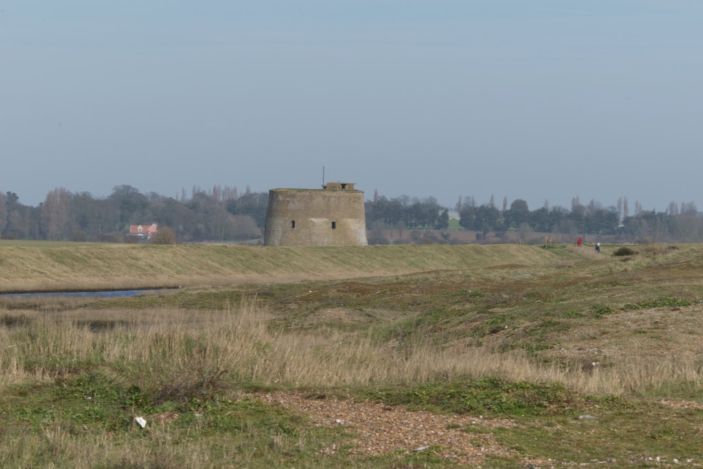
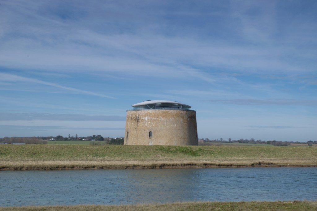
Key to the guarding against Little Bony was a line of Martello towers built in the southeast and extending into Suffolk as far as Aldeburgh. We had six on the Peninsula, cutely named V to Z and then the last AA. Some still exist and can be pretty photogenic for brick monsters. They would have been a frightening proposition to any potential invader. Round with thick walls and a 24-pound gun that could traverse through 360-degrees. Based on the 1565 version in Corsica, the towers were garrisoned with one officer and up to twenty-five men. Interestingly they were misnamed or purposely misnamed. There is a lot of misnaming that has gone on over history in this country of ours, Beef, Pork, Cafe etc. and that I think this makes us quintessentially English. Of course, there are English words adopted by the other countries, especially those that felt the hand of suppression from the English.
Some Martello Towers still exist today and have lasted from the early 19th century. While they missed their original purpose, they have served various guises over time. They were pretty much redundant by 1850 because of the introduction of gun rifling, which meant that they would not be able to cope with the destructive power of the then modern guns. The Towers on the Peninsula started at Bawdsey with Tower V on the corner of the North Sea and the mouth of the Deben. Unfortunately, V did not see out the century because when Sir Cuthbert Quilter built his pile, Bawdsey Manor, he did not see the attraction of a Martello Tower in his back yard and reduced it to a sunken garden which I understand is still visible today. It was not the only change he made to the Peninsula, and he added game woods in place of farmland and ancient heath to allow his pheasants and other birds to hide in until they were rudely chased out to be shot by his guns.
Further up the coast sitting above the beach near to a small promontory and protected from the eroding sea by massive boulders, sits Tower W. This is part of a small cluster of buildings consisting of two houses and the tower. It also shares the area with some impressive World War 2 defences. Martello X was washed into the sea early in the 20th century, a genuine danger with the cliffs and foreshore being as soft as butter. Martello Y is perhaps the most outstanding, not just as a defensive monument but as a holiday home. Featured as a destination on Sandi Toksvig’s Extraordinary Escapes TV program, it is the ‘perfect get away from it’ break, which took a great deal of money to turn it from a cold, unwelcoming military lump to a bijou des res at around £3000 for a week’s stay. Martello Tower Z is unused, and AA sits close to the lovely hamlet of Shingle Street, one of my favourite places on the coast. So the Martello Towers live on, not just as a photographer’s dream, but as dwellings, holiday homes and one a stalwart edifice awaiting re-purposing. Were these edifices a waste of money? Well, not if Bonaparte had made it across the Channel and up the North Sea.
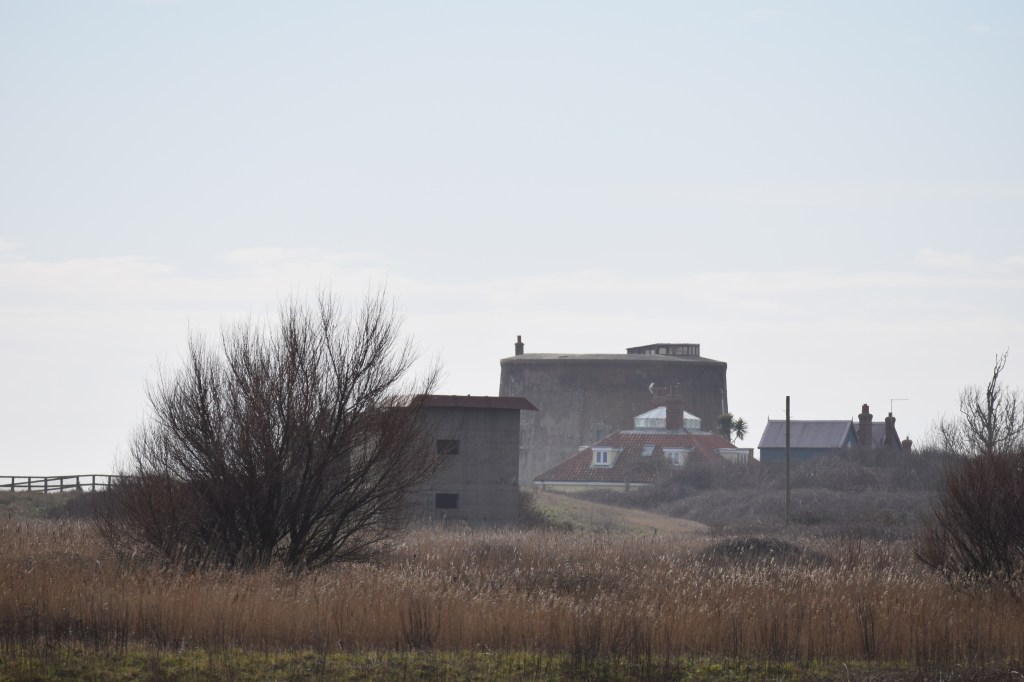
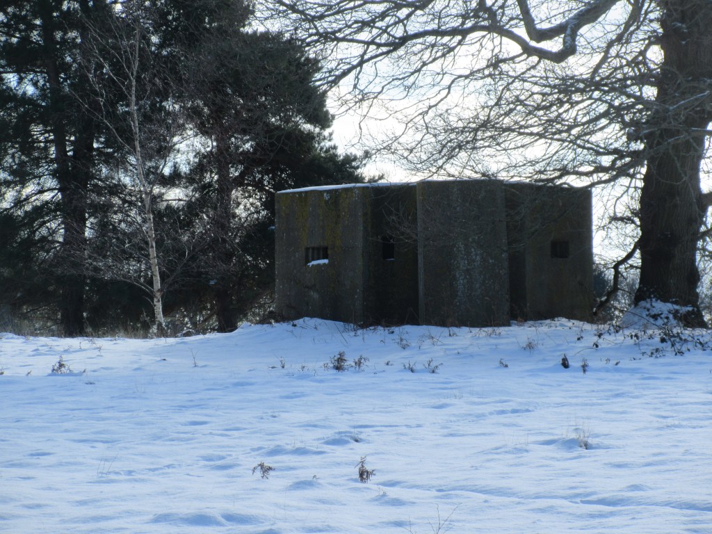
I first got the idea for this blog with the sudden realisation of the identity of a ruin that stood on a corner of the road to Ramsholt. We kept seeing the mound on the return from one of our walks from Shottisham to Ramsholt Quay. We always stroll across the fields on the way down, passing by the charming round towered All Saints church and then by road on the way back. Shortly before you reach Alderton road, you see on the last corner what looks to be an earth mound on one side and an old building forming the other side. I looked at old ordnance survey maps to try and find its date, and then it occurred to me that it may be some kind of war defence. So after a short bit of Googling, I found the ‘Pillbox Study Group’ website with a picture of the Building from 14 years ago.
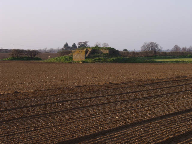
What we thought was an old farm building was a special type of Pill Box known as a Starfish Decoy. It had two rooms and a protective wall in front of the opening, and was in reasonable condition in 2018 when ‘Tom Outdoors’ posted a video of the inside on Youtube.
Following the bombing of Coventry, Colonel John Turner was given the task of creating decoys to look like airfields and burning cities that would cause the Luftwaffe to drop their bombs harmlessly in the countryside. Noted by their letter identification, there were different types of Decoys, and this is where it gets a little tricky because I get various letters with legends which differ according to the Web publication. What is clear is that K sites were dummy airfields or factories and Q night sites, which Turner implemented to simulate airfields or cities on fire. Our Shottisham site known as QL/SF type, with the SF indicating Star Fish and having a designation C32a. The site would be manned, and it had two generators and some communication equipment. More worrying for the Army personnel was the decoy equipment was only 500 yards away from the Starfish box. The decoy would have been fire baskets set in frames with a detonator below. When bombers were spotted on their way to bomb our cities, perhaps identified at the Coastal Bawdsey Radar Station, the fire baskets were lit with the one purpose to entice the bombers to drop their bombs in that area. This site was set up to protect Ipswich just a few miles west and the factory of Ransome Sims and Jefferies. They were engaged in the manufacture of war products rather than agricultural machinery, which was their pre-war trade.
When you look at a map, you can see that the starfish site is directly east from Ipswich, and if you were flying from Germany, you would expect, or perhaps not expect to fly over the place. If I been a pilot and had managed to get past the coastal batteries, I would drop my bombs on the first available target. It was customary for the Q sites to be more than 1 mile from Cities, Towns and Villages, but necessarily this may not always have been the case. What is interesting is that it is less than a mile from the Sorrel Horse Inn, which hosted the Sutton Hoo archaeological team in 1939, so I wonder if it also served the soldiers that operated the Q site and other emplacements in the area. Difficult to confirm this because, unlike the Sutton Hoo diggers photos, there is a lack of similar pictures having been taken.
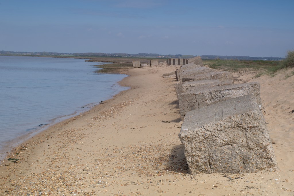
This area of the Peninsula was purpose-made for an invading army once you overcome the very marshy nature of some areas near the coast. The small number of roads and tracks would allow your heavy and light armoury to negotiate boggy bits to get to the wide-open fields and a small number of villages which without help would not have stood in the way of the invaders. Several cliffs would have reduced the entry points. If you were negotiating your landing craft up the estuary of River Deben, you would have the worrying ‘Deben Bar’ to negotiate. One of my books, ‘Up The Deben’ by Robert Simper, has a picture of the bar in a northeasterly with an ebb tide, and it is a vortex of angry water. However, once you are over the bar, you have plenty of beach landings with some hards and slipways. It occurred to the War Ministry or whoever that if we were going to repel the threatened invasion, it would be necessary to beef up the defences, and it would take some innovative creations. We are not talking Dad’s Army, although who would have thought decoys! Even Clive Dun’s upturned bath on pram wheels may have taken 2nd place to the crazy ideas. However, some of the defences were simple, like blocks of concrete along a beach, and some were more impressive, like the twin-gun emplacement at East Lane Bawdsey. If you can get a ‘A GUIDE TO SECOND WORLD WAS ARCHAEOLOGY IN SUFFOLK’ Guide 3: Orford to Felixstowe by Robert Liddiard and David Sims it has some interesting maps showing the defences in this area. Flame Fougasse, which is a type or bread, is also a pit filled with petrol and an explosive charge which projects onto your invading army. Frightning.
Bawdsey Battery is a significant concrete construction completed in 1942 and was manned by 332 Battery Royal Artillery, who were transferred from Foulness to Bawdsey with their guns. The emplacement had two guns with partially sunken magazines and searchlights on either side of the guns. The construction is still quite impressive, although it has its fair share of graffiti; even so, you can see how seriously they took the defence of this area. A little back from the battery is an observation post set on three stories with a basement. The top story was an armoured roof which with a corner post that allowed all-round vision. The corner posts have failed, allowing the roof to fall into the main building. On the other side of the road from the observation post is a round pillbox of first world war vintage. This battery would have been instrumental in stopping some of the Heinkels on their way to Ipswich.
On our little patch, there were some impressive implementations. Take the two gun emplacements which were on the north side of the village.
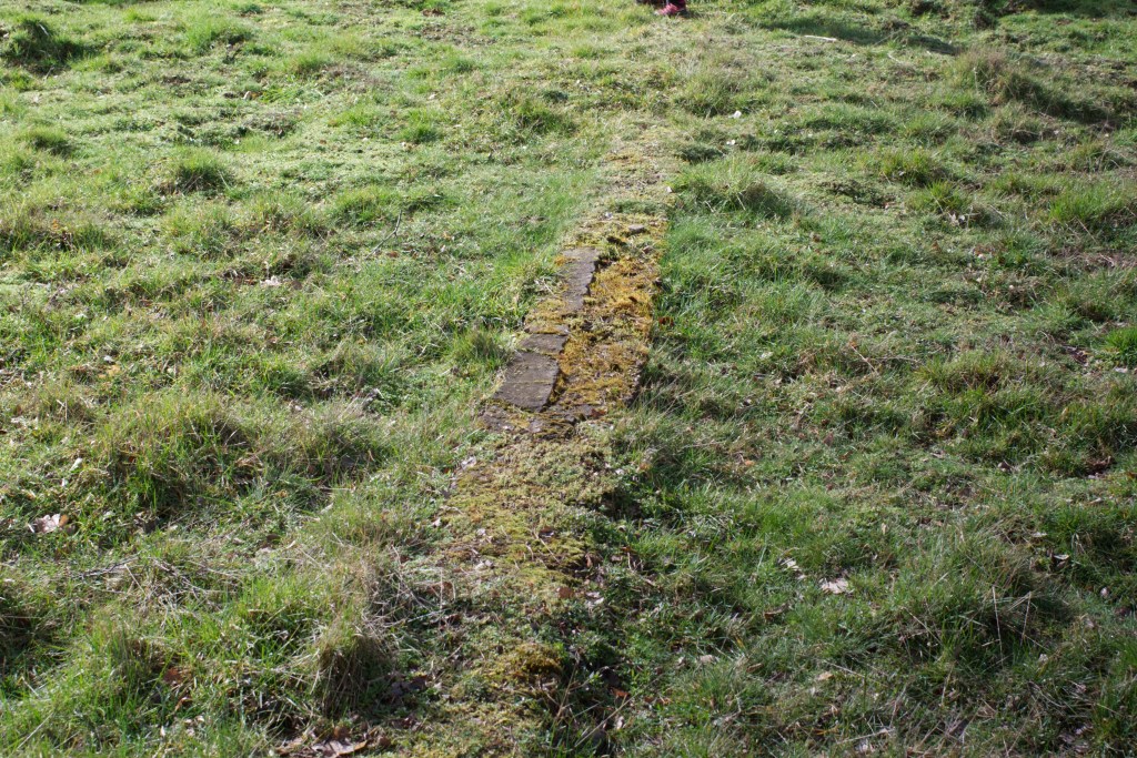
We had two gun batteries and a pillbox in the same area. The pillbox shown in the opening photo is East of the first gun battery, which would have been back against the trees in the image above. The second battery was east of this position and the pillbox. When we were checking the pillbox for the first time, we found some foundations to the north of the pillbox. We have taken some photos, one of which is reproduced here. These foundations are a bit of a mystery because the location has been a scrub/wood since before the 1880s. It would be unusual to find a building in a wood, so we suggest that these foundations may have been part of a building of the same age as the pillbox, perhaps a shell magazine. It would be interesting to know.
The guns which would have formed the first battery would have been three 6″ howitzers which would have been more manoeuvrable than the four 9.2″ guns that would have been at the second location. The 9.2″ gun would have been delivered in pieces and built on site. I am unsure how long it took to build, although it took 36 hours to dismantle. The 6-inch gun was often on pneumatic tyres and was available to the Army from 1917, so they had a reasonable life span of design if they were still in use in 1940. For someone who knows little about guns, big or small, I am impressed by the firepower of these monsters. The 9.2″ inch, if it was the MK2 version, could hurl a 290-pound high explosive shell some 14,000 yards. I am quoting imperial because this blog is about 1940 weaponry and metric was only a dream then. The fire plan for the 9.2″ gun was to hit anything from the Deben east of Ramsholt to the North Sea coast south of Shingle Street, and the 6″ gun, which could hurl an 86 pound shell 11,400 yards and was aimed at an arc from Bawdsey Manor to the North Sea North at Hollesley Bay. When these mega machines starting rolling into the village, and I am assuming they would have rumbled past Sutton and to the site past Vale Farm, the war must have begun to feel very real to any civilian onlookers if it did not feel like it already. The following is memory of a Villager from war time,
The pub landlord George Bennett & his wife Kate were very kind to us, we used to go over and sit in the bar, when the air raids were passing over. These were fired at by the anti-aircraft batteries situated at Vale Farm etc. these were also picked out by the searchlights located in Woodhall meadows. (Our dad was in the navy at this time)
Now, he mentions Anti-aircraft and I am not sure whether an Howitzer could be an anti-aircraft gun or maybe they had those there as well.
Another Villager recalls that the Army took over the School which is now a private dwelling. They built a tank over the well and would pump water into the tank, fill up bowsers and transport the water to the troops camped at Vale Farm by the guns. He remembers the squaddies coming into the village to drink at the Sorrel Horse Inn, as it was called then, but only when there was beer. He remembers the pub had a sign one time which said “No Beer, Oh Dear”.
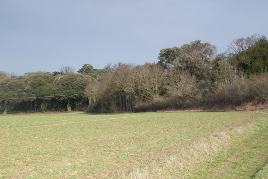
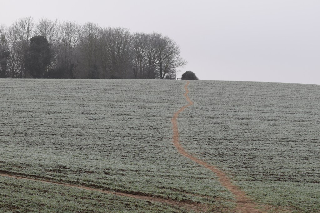
To the south of the gun emplacements on the rise above the west end of the Village were two observation posts. These would have been about where the Trust Hall and Forge House are as far as we can tell. Observation posts were crucial for the direction and distance that guns would have needed to fire. If you look at the photo below, you will see how much the guns would not have seen when looking from the gun emplacement. Just the top of the hill and beyond is the Village. There were several artillery observation points South and East of Shottisham to guide the guns to targets.
Although there is nothing to see now, they must have been a few hundred yards from the village road at the top of the rise.
As far as Shottisham goes, that was about it as far as defences are concerned from what I can find. There was a pillbox in Sutton, but if the invader, interested only in total dominance, managed to get past the defences in Bawdsey, Alderton and Shottisham, they had free rein until they got to the top of the hill to the junction of the B1083 and B1084 when they would have been faced with the quite a few defence fortifications including pillboxes and command posts. Although I am not sure, I assume that the then smaller Wilford Bridge would have been destroyed to slow their progress. They would have needed to go some way North East to make any progress unless they brought those boat bridges with them.
So the tiny village of Shottisham would have, and hopefully did, play some small part in the defence of this country in its last threat of invasion. There are now just few people who remember these times and they were quite young. The number of residents was a lot more than now although there was no running water and no mains sewage and no electricity. Water would have come from wells or water pumps, gas lamps or candles providing light at night and cess pits providing waste collection. It was not until 1950 that people had motorised transport, mostly motorcycles, and were free to motor into the surrounding area something that would probably been denied them without the defences in this area and others.
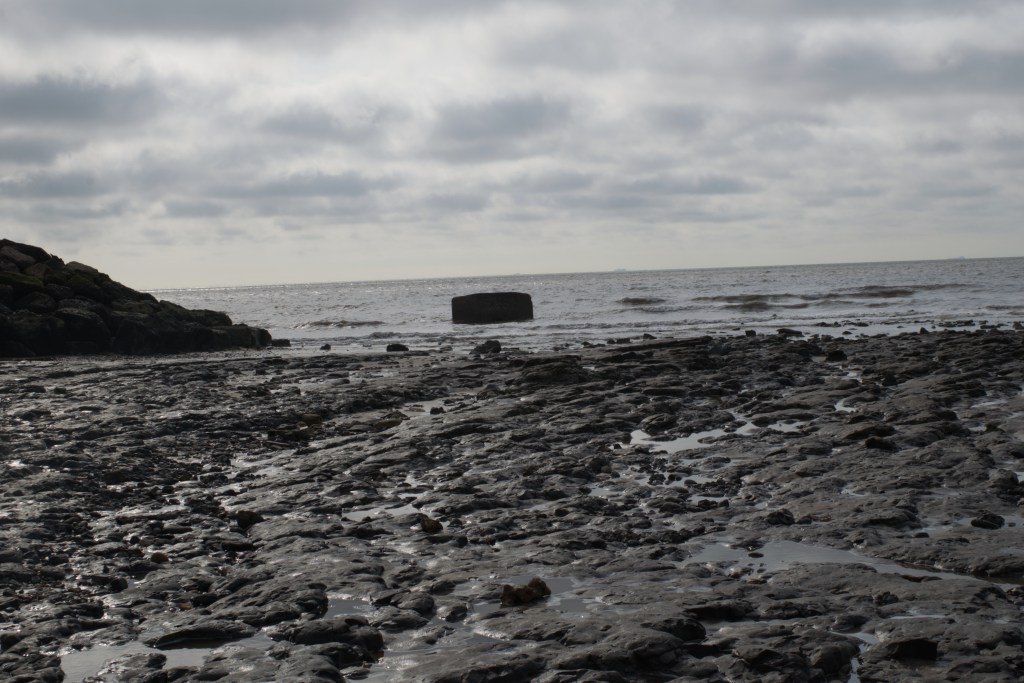
Pillbox in the sea at Bawdsey on grey spring morning
